The university awards a Bachelor of Science Degree with a major in Geomatics upon successful completion of the Geomatics curriculum. Geomatics majors must earn a grade of C or better in all required mathematics, physics and geomatics courses. Each semester Geomatics students will be responsible for showing thorough documentation that they have performed 30 hours of service learning. This documentation will be a weekly form filled out and submitted to the secretary for the department of Applied Sciences. Completion of the curriculum will prepare one for mid level positions in land surveying, construction surveying, mapping and other related areas. The curriculum meets the educational requirements for registration as a professional land surveyor in the State of Louisiana and the eligibility requirements to take the “Surveyor in Training” examination.
COURSE SEQUENCE FOR GEOMATICS PROGRAM (PDF DOWNLOAD)
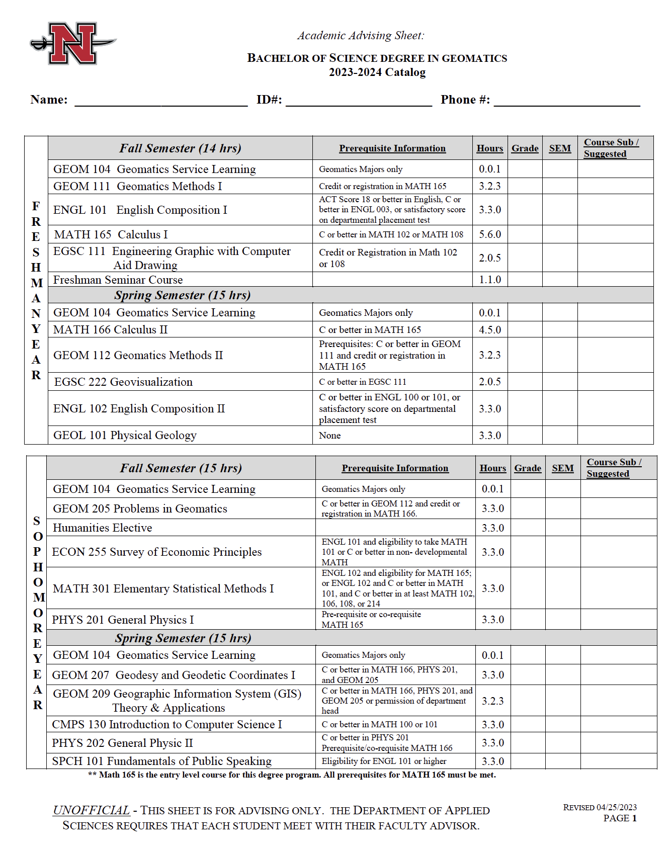
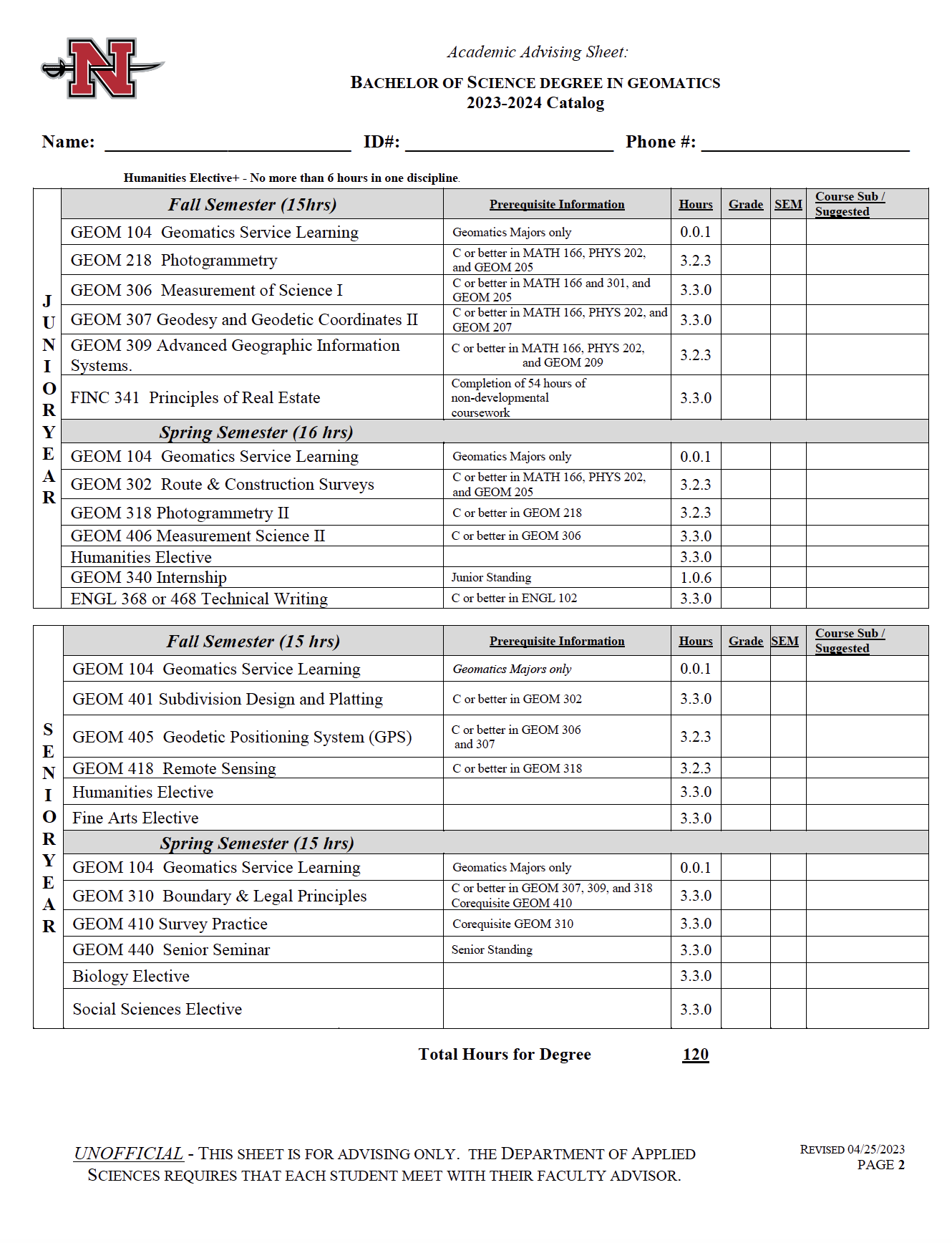
GEOMATICS ADVISING SHEET NEW CURRICULUM
Incoming and current Geomatics students are eligible for a variety of local, state and national scholarships.
Nicholls offers the following scholarships to Geomatics students:
LOUISIANA SOCIETY OF PROFESSIONAL SURVEYORS EDUCATION FOUNDATION SCHOLARSHIP $1000 is awarded to a full-time freshman majoring in Geomatics, and the recipient must maintain a 3.00 or above overall GPA.
T BAKER SMITH SCHOLARSHIP is awarded to a full-time student enrolled in Geomatics. Recipient must have a minimum overall grade point average of 2.75. Each scholarship is valued at $2500 per semester.
JULES ORESTE CHUSTZ MEMORIAL ENDOWED SCHOLARSHIP FOR GEOMATICS This endowed scholarship will fund ten to twelve new $1,000 annual awards. We plan to distribute it equally among freshmen, sophomore, junior, and senior years. The criteria will be set by the Geomatics faculty every academic year.
mph INC., EXCELLENCE IN GEOMATICS SCHOLARSHIP Two $1000 annual awards are awarded to qualifying incoming freshman who are maintaining a 3.0 or above overall GPA. One $1000 annual award is awarded to qualifying minority (preference will be given to women). Two $1000 annual awards for existing Geomatics majors in good academic standing.
CONTRACTOR’S EDUCATIONAL TRUST FUND ENDOWED SCHOLARSHIP
For more information call 985-448-4693.
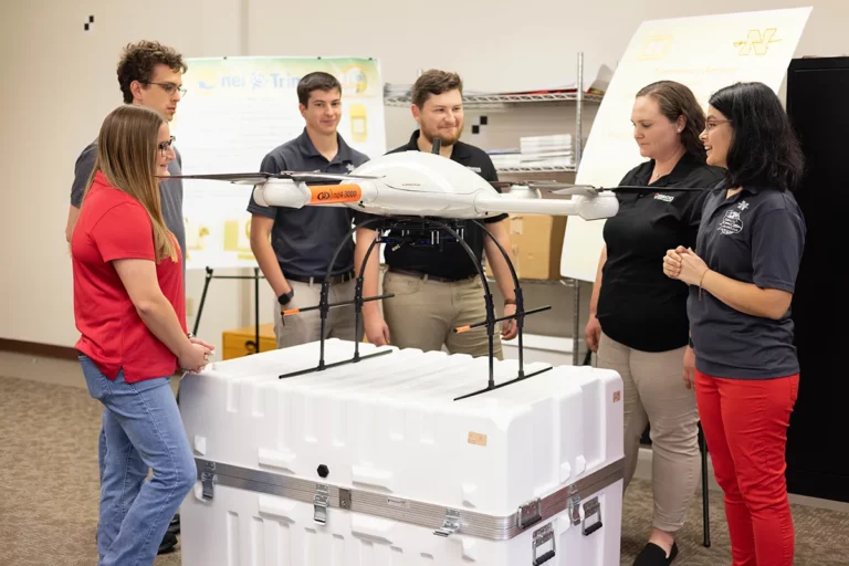
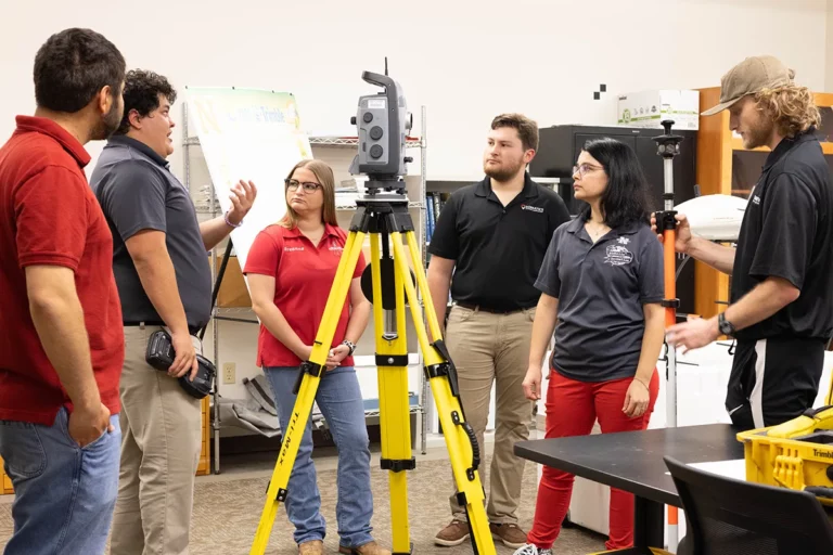
What is Geomatics?
Geomatics is the art, science, and technology of establishing the relative and/or precise positions of points and features near the Earth’s surface. Geomatics involves the following disciplines:
- Land Surveying – The establishment or retracement of land parcel boundaries.
- Construction Layout – The location of construction projects on the ground.
- Land Development – The design and location of subdivisions for people to live.
- Geodesy – The science of determining the size and shape of the Earth.
- Cartography – The art and science of making maps.
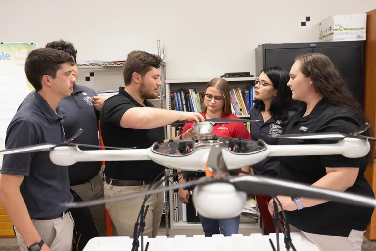
- Remote Sensing – The use of cameras and other sensors to measure land forms and vegetation on the Earth.
- Photogrammetry – The use of vertical photographs to map the surface of the Earth.
- Geographic Information Systems (GIS) – The use of software to tie together particular features with their location on the Earth.
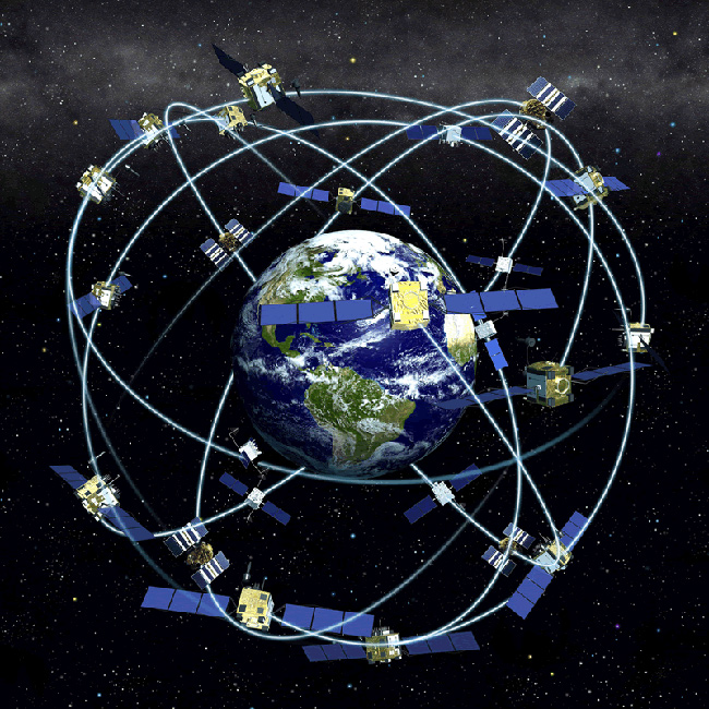
- Global Positioning Systems (GPS) – The use of satellites to determine the precise location of features on the Earth.
What are the fundamental skills required for a career in Geomatics?
A good high school background in mathematics and science is desirable for studies in Geomatics. While much of the work involved the application of trigonometry and plane geometry, an understanding of calculus is required to understand how error in the measurement affect the products desired by clients. Increasingly, the technologies utilized by the Geomatics Professional involve the propagation of light energy. The use of such technologies is benefitted by the knowledge of physics describing how light propagates in the atmosphere. The student can expect to use precise sensitive equipment to make measurements on the Earth and to process those measurement into useful products using computer software.
Is Geomatics an Engineering program?
A broad definition of engineering is the application of mathematics and applied science in order to solve the needs of clients. In this sense, Geomatics is an engineering discipline. The explosion of measurement technology has caused the body of knowledge necessary for success in the profession to require its own engineering studies. Also, the path to licensure as a Geomatics Professional is unique.
Why do I need to be licensed as a Geomatics Professional?
All states require Geomatics Professional’s practicing in the Land Surveying discipline to be licensed to protect the citizens of that particular state. Licensure involves the passage of national examinations, a state specific examination, and work experience acceptable to the respective state licensure board. Licensed professionals generally earn more and experience more work responsibilities. While Licensure is desirable, it is not necessary for a productive and profitable career in Geomatics.
Why is the choice of a career in Geomatics so desirable?
A wide range of career opportunities lie ahead of the graduate with a four-year degree in Geomatics. Our society need educated professionals to analyze and produce products produced by measurements of features on the Earth’s surface. These measurements are commonly referred to as spatial data. Many professionals like the overall project oriented nature of the work. They also enjoy traveling to different locations in order to gain spatial data. Many professionals also like to work outside in nature, while others like to process spatial data in the office producing maps or products necessary for clients. Other professionals like the fact that the profession rewards the application of mathematics. Since the Geomatics Professional is desired in all communities, both large and small, work is available in large and small businesses across the nation. Frequently, Geomatics Professionals establish successful businesses in order to serve their communities. Geomatics (geospatial technologies) is also listed as one of the Top 3 emerging industries by the U.S. Department of Labor and U.S. Department of Education.
Can you give some representative examples of jobs typically performed by the Geomatics Professional?
The following are examples of jobs that are performed by Geomatics Professionals. Please note that this list does NOT cover the wide range of possible jobs and tasks that are available:
- Locating the boundary lines of a parcel purchased for commercial development.
- Dividing a parcel into lots for a land development project.
- Negotiating a contract for the photograph necessary to a large scale map.
- Producing a map showing the features of a parcel for a client.
- Determining the elevation of a parcel being considered for development.
- Mapping vegetation for wetland delineation and monitoring.
- Managing the use of mobile mapping technologies for monitoring roads and bridges.
- Marking the location for proposed construction projects.
- Using satellite technology to precisely locate point of critical importance such as nuclear power plants and hydro-electric dams.
- Using Geographic Information Systems (GIS) Software and measurement data to optimize the location of transportation hubs and routes.
How are the job prospects for the Geomatics Professional?
The profession of Geomatics is changing in a way that benefits the graduate with a four-year degree in Geomatics. The explosion in technology requires an understanding of math and applied science and its application to measurement science. Graduates are in high demand by companies who reply on the successful application of emerging technologies to remind successful and competitive in a ever-changing business climate.


Industry advisory boards for each of the Department of Applied Sciences’ programs ensure that the faculty is addressing industry needs and emerging industry trends through their curricula.
Members of the Nicholls Geomatics Program Advisory Committee:
Mr. Charles Coyle Sr., PLS
Past President of LSPS
Coyle Engineering and Land Surveyors
Bossier City, LA
Mr. Charles Coyle III, PLS
Past President of LSPS
Coyle Engineering and Land Surveyors
Bossier City, LA
Mr. Clifford Smith, PLS
Past President of LSPS
T Baker Smith, LLC
Houma, LA
Mr. David L. Paterson, PLS
Past Member of Louisiana Professional Engineering and Land Surveying Board
Past President of LSPS
LandSource, Inc.
Baton Rouge, LA
Mr. James B. Pellegrin, PLS
Consulting Engineers and Land Surveyors
Galliano, LA
Mr. Jimmy Chustz, PLS
Chustz Surveying, LLC
New Roads, LA
Mr. John Hebert, PLS
Mph, Inc.
Houma, LA
Mr. Kappy Cullum, PLS
C & R Land Surveying, LLC
Broussard, LA
Mr. Morris Hebert, PLS
Past President of LSPS
Past Member of LA Board of Regents (BoR)
Past Member of Louisiana Professional Engineering and Land Surveying Board
Mph, Inc.
Houma, LA
Mr. Paul Kocke, PLS
Past President of LSPS
Gandolfo Kuhn, LLC
Harahan, LA
Mr. Ricardo M. Johnson, PLS
Director of Coastal Services
Chairman of LSPS Elevation Committee
Lafayette, LA
Mr. Stanley Ard, PLS
Past President of LSPS
Louisiana Department of Transportation and Development
Mr. Steven Flynn, PLS
Past President of LSPS
Riverland Surveying Company, LLC
LaPlace, LA
Mr. Timothy Allen, PLS
Past member of Louisiana Professional Engineering and Land Surveying Board
Apache Corporation
Houma, LA
Mr. Vic Weston, PLS
Board Member of LSLBC
Mr. Will Fontenot, PLS
Forte & Tablada, Inc.
Baton Rouge, LA
Mr. Brad Holleman, EI, PLS
Current President of LSPS
Denham Springs, LA
ACADEMIC MEMBERS:
Dr. Esra Tekdal Yilmaz
Assistant Professor of Geomatics
Department Head of Applied Sciences
Morris&Sandra Hebert Endowed Professor
Nicholls State University
Dr. Balaji Ramachandran
Associate Professor of Geomatics
T Baker Smith Endowed Professor
Contractors Educational Trust Fund Super Endowed Professor
President Elect Surveying and Geomatics Educators Society
Geomatics Program Coordinator
Nicholls State University
Dr. John Dennis
Assistant Professor of Geomatics
Nicholls State University
Dr. Terry Dantin
Professor Emeritus
Nicholls State University
| Total Undergraduate Enrollment | Degrees Awarded | ||
| Part Time | Full Time | Bachelors | |
| Fall 2021 | 9 | 27 | TBA |
| Fall 2020 | 3 | 42 | 3 |
| Fall 2019 | 3 | 36 | 8 |
| Fall 2018 | 5 | 38 | 6 |
| Fall 2017 | 5 | 32 | 4 |
| Fall 2016 | 7 | 23 | 2 |
| Fall 2015 | 4 | 26 | 5 |
| Fall 2014 | 10 | 28 | 11 |
| Fall 2013 | 10 | 47 | 11 |
| Fall 2012 | 13 | 51 | 8 |
EDUCATIONAL OUTCOMES:
- Comprehensive knowledge of the fundamental principles of Geomatics and Land Surveying.
- Proficiency in the practice of surveying and related mapping disciplines.
Preparedness for graduate or advanced technical education. - Understanding and appreciation of how local experience translates to societal and global needs.
- Commitment to lifelong learning and professional and leadership developments.
![]()
In the United States, surveyors are licensed at the state level by professional licensing boards. Surveying boards confer the P.S. license when licensure candidates meet a combination of requirements in education, experience, and exams. Before registering for an upcoming NCEES surveying exam, review your state’s unique approval and registration process by selecting your state or territory from the map or drop-down list below.
The FS and PS exams are administered via computer-based testing. Registration is open year-round. Contact your state licensing board directly for information about state-specific surveying exams.
![]()
Nicholls State University meets NC-SARA requirements. MORE INFO HERE>
SARA – the State Authorization Reciprocity Agreement – is an agreement between member states, territories and districts of the United States of America. As of July 2019, 49 states (all but California), the District of Columbia, Puerto Rico and the U.S. Virgin Islands have joined SARA.
SARA provides a voluntary, regional approach to state authorization of postsecondary distance education. SARA member states assume the principal responsibility of ensuring that SARA policies are followed by the institutions they approve to participate in SARA – policies designed to result in high-quality distance education offerings being available to students around the country. Institutions approved to participate in SARA enjoy a streamlined approach to securing approval to offer distance education/online programming in SARA member states.