Nicholls State University

RISING INDUSTRY
Geomatics is listed as one of the Top 3 emerging industries by the U.S. Department of Labor and U.S. Department of Education.
100% JOB PLACEMENT
Nicholls geomatics students are in high demand, often receiving multiple job offers before graduation.
Previous slide
Next slide

GEOMATICS / SURVEYING PROGRAM

Nature of Program: The Bachelor of Science Degree Program in Geomatics is designed to offer college level preparation for recent high school graduates and for those already working in the field of land surveying to meet the educational requirements for registration as a Professional Land Surveyor in the State of Louisiana.  The program is based on standards necessary to attain accreditation by the Accreditation Board for Engineering and Technology (ABET).

Definition of Geomatics: “Geomatics” is the new name rapidly becoming synonymous world wide with the term “Surveying”.  Surveying has traditionally been defined as “the science, art, and technology of determining, or of establishing, the relative positions of points above, on, near, or beneath the earth’s surface.”  Geomatics includes the traditional surveying definition along with surveying’s steadily increased importance with the development of new technologies and the growing demand for a variety of spatially related types of information, particularly in measuringand monitoring our environment.  Increasingly critical are areas of expanding populations, appreciating land values, dwindling natural resources, and the continuing stressing of the quality of our land, water and air from human activities.

Objectives of the Program:  The Geomatics Program will provide education in the way land form and spatial data are measured, recorded, processed, stored, retrieved and shared by the use of conventional methods and new technologies in Global Positioning Systems, Land Information Systems and Geographic Information Systems, and will align with the increasing demands by society for more data with increasing higher standards of accuracy.

Geomatics Program graduates will demonstrate:

  1. Comprehensive knowledge of the fundamental principles of Geomatics and Land Surveying.
  2. Proficiency in the practice of surveying and related mapping disciplines.
  3. Preparedness for graduate or advanced technical education.
  4. Readiness for professional employment in Geomatics and Land Surveying.
  5. Understanding and appreciation of how local experience translates to societal and global needs.
  6. Commitment to lifelong learning and professional and leadership developments.

Student Outcomes

  1. An ability to identify, formulate, and solve broadly defined technical or scientific problems by applying knowledge of mathematics and science and/or technical topics to areas relevant to the discipline
  2. An ability to formulate or design a system, process, procedure or program to meet desired needs. 
  3. An ability to develop and conduct experiments or test hypotheses, analyze and interpret data and use scientific judgment to draw conclusions.
  4. An ability to communicate effectively with a range of audiences.
  5. An ability to understand ethical and professional responsibilities and the impact of technical and/or scientific solutions in global, economic, environmental, and societal contexts.
  6. An ability to function effectively on teams that establish goals, plan tasks, meet deadlines, and analyze risk and uncertainty.  


The Geomatics Program addresses the needs of the Louisiana State Board of Registration for Professional Engineers and Land Surveyors, and the Louisiana Society of Professional Surveyors.

The use of traditional course scheduling, distance learning technologies, on-site course offerings, and internships will maximize educational opportunities for both the traditional and nontraditional students.  ABET accreditation requirements insure that sufficient faculty and facilities will be available so that courses can be offered in a timely manner.  Professional accreditation will enhance graduate credentials enabling them to find employment in a variety of professional areas both in state and nationally.

GEOMATICS CIRRICULUM

The geomatics program educates students in the way landform and spatial data are measured, recorded, processed, stored, retrieved and shared by the use of conventional methods and new technologies in geographic information systems, land information systems and global positioning systems. The program also prepares students to face the increasing demands by society for more data with increasingly higher standards of accuracy.

Traditional courses, distance learning technologies and internships maximize educational opportunities for both traditional and nontraditional students. Classes for the Professional Land Surveyor Certification have been incorporated into the geomatics program.

Students graduating from the Nicholls geomatics program:

  • know the theories and methods of measuring
  • understand other methods of collecting information about the physical earth and environment
  • know how to process the gathered information and then how to best prepare a presentation of that information
  • have a general knowledge of the basic laws governing the decisions to be made during the processing of information and
  • have the academic course requirements to be registered as a professional land surveyor

Learn more about the geomatics program and courses by visiting the Nicholls catalog.

The university awards a Bachelor of Science Degree with a major in Geomatics upon successful completion of the Geomatics curriculum. Geomatics majors must earn a grade of C or better in all required mathematics, physics and geomatics courses. Each semester Geomatics students will be responsible for showing thorough documentation that they have performed 30 hours of service learning. This documentation will be a weekly form filled out and submitted to the secretary for the department of Applied Sciences. Completion of the curriculum will prepare one for mid level positions in land surveying, construction surveying, mapping and other related areas. The curriculum meets the educational requirements for registration as a professional land surveyor in the State of Louisiana and the eligibility requirements to take the “Surveyor in Training” examination.

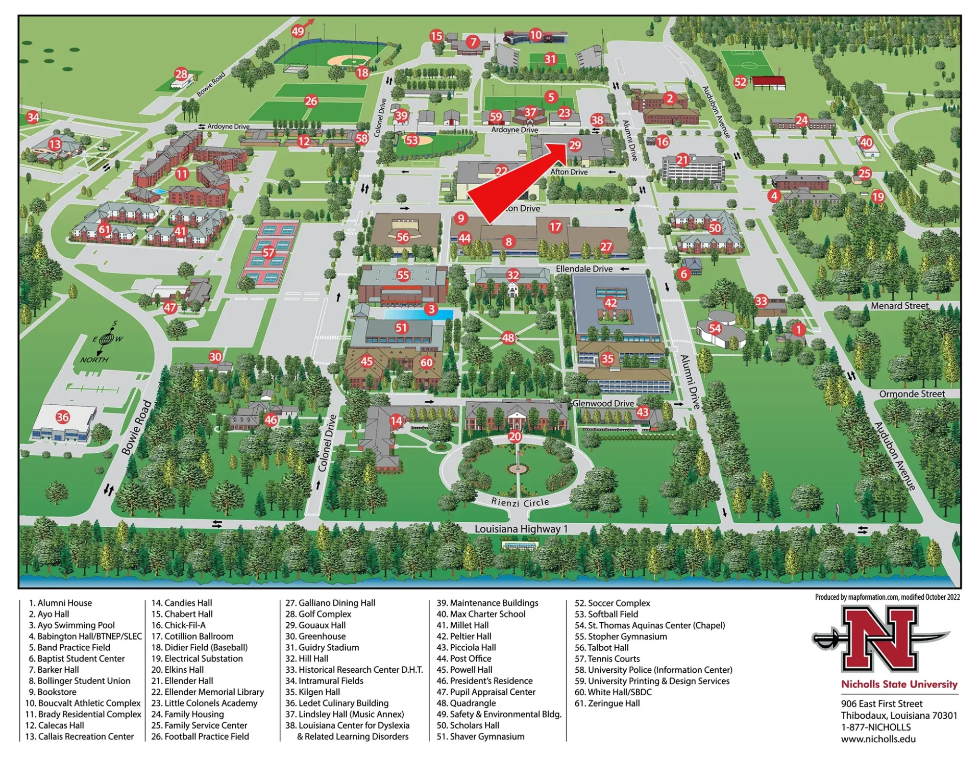
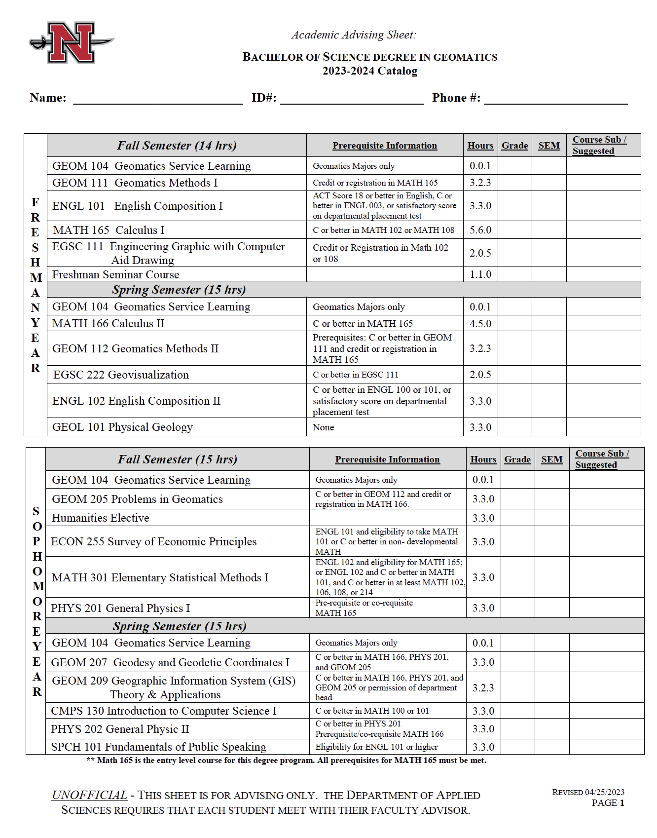
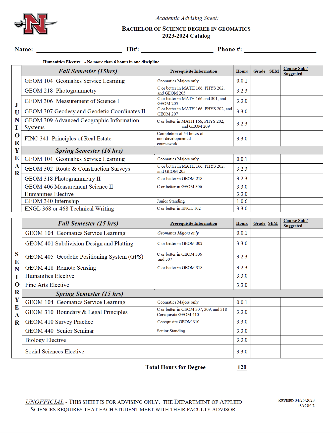
COURSE SEQUENCE FOR GEOMATICS PROGRAM (PDF DOWNLOAD)

GEOMATICS ADVISING SHEET NEW CURRICULUM


Incoming and current Geomatics students are eligible for a variety of local, state and national scholarships.

Nicholls offers the following scholarships to Geomatics students:

LOUISIANA SOCIETY OF PROFESSIONAL SURVEYORS EDUCATION FOUNDATION SCHOLARSHIP $1000 is awarded to a full-time freshman majoring in Geomatics, and the recipient must maintain a 3.00 or above overall GPA.

T BAKER SMITH SCHOLARSHIP is awarded to a full-time student enrolled in Geomatics. Recipient must have a minimum overall grade point average of 2.75. Each scholarship is valued at $2500 per semester.

JULES ORESTE CHUSTZ MEMORIAL ENDOWED SCHOLARSHIP FOR GEOMATICS  This endowed scholarship will fund ten to twelve new $1,000 annual awards. We plan to distribute it equally among freshmen, sophomore, junior, and senior years. The criteria will be set by the Geomatics faculty every academic year.

mph INC., EXCELLENCE IN GEOMATICS SCHOLARSHIP Two $1000 annual awards are awarded to qualifying incoming freshman who are maintaining a 3.0 or above overall GPA. One $1000 annual award is awarded to qualifying minority (preference will be given to women). Two $1000 annual awards for existing Geomatics majors in good academic standing.

CONTRACTOR’S EDUCATIONAL TRUST FUND ENDOWED SCHOLARSHIP

For more information call 985-448-4693.

What is Geomatics?

Geomatics is the art, science, and technology of establishing the relative and/or precise positions of points and features near the Earth’s surface. Geomatics involves the following disciplines:

  • Land Surveying – The establishment or retracement of land parcel boundaries.
  • Construction Layout – The location of construction projects on the ground.
  • Land Development – The design and location of subdivisions for people to live.
  • Geodesy – The science of determining the size and shape of the Earth.
  • Cartography – The art and science of making maps.
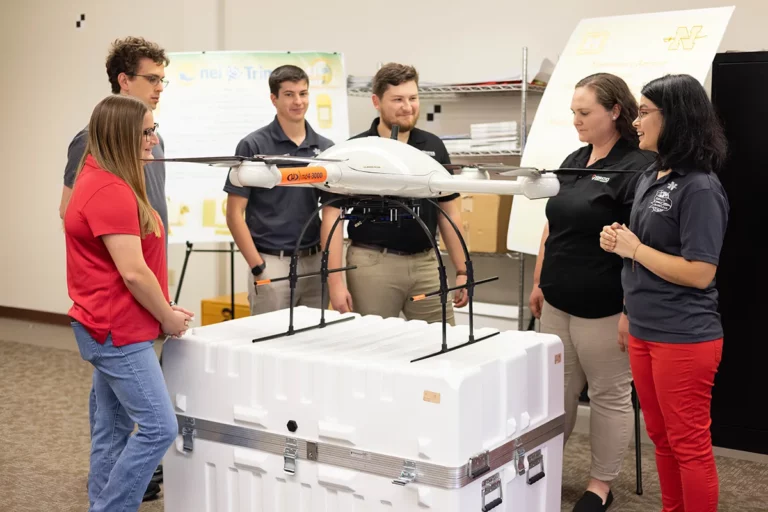
  • Remote Sensing – The use of cameras and other sensors to measure land forms and vegetation on the Earth.
  • Photogrammetry – The use of vertical photographs to map the surface of the Earth.
  • Geographic Information Systems (GIS) – The use of software to tie together particular features with their location on the Earth.
  • Global Positioning Systems (GPS) – The use of satellites to determine the precise location of features on the Earth.

What are the fundamental skills required for a career in Geomatics?

A good high school background in mathematics and science is desirable for studies in Geomatics. While much of the work involved the application of trigonometry and plane geometry, an understanding of calculus is required to understand how error in the measurement affect the products desired by clients. Increasingly, the technologies utilized by the Geomatics Professional involve the propagation of light energy. The use of such technologies is benefitted by the knowledge of physics describing how light propagates in the atmosphere. The student can expect to use precise sensitive equipment to make measurements on the Earth and to process those measurement into useful products using computer software.

Is Geomatics an Engineering program?

A broad definition of engineering is the application of mathematics and applied science in order to solve the needs of clients. In this sense, Geomatics is an engineering discipline. The explosion of measurement technology has caused the body of knowledge necessary for success in the profession to require its own engineering studies. Also, the path to licensure as a Geomatics Professional is unique.

Why do I need to be licensed as a Geomatics Professional?

All states require Geomatics Professional’s practicing in the Land Surveying discipline to be licensed to protect the citizens of that particular state. Licensure involves the passage of national examinations, a state specific examination, and work experience acceptable to the respective state licensure board. Licensed professionals generally earn more and experience more work responsibilities. While Licensure is desirable, it is not necessary for a productive and profitable career in Geomatics.

Why is the choice of a career in Geomatics so desirable?

A wide range of career opportunities lie ahead of the graduate with a four-year degree in Geomatics. Our society need educated professionals to analyze and produce products produced by measurements of features on the Earth’s surface. These measurements are commonly referred to as spatial data. Many professionals like the overall project oriented nature of the work. They also enjoy traveling to different locations in order to gain spatial data. Many professionals also like to work outside in nature, while others like to process spatial data in the office producing maps or products necessary for clients. Other professionals like the fact that the profession rewards the application of mathematics. Since the Geomatics Professional is desired in all communities, both large and small, work is available in large and small businesses across the nation. Frequently, Geomatics Professionals establish successful businesses in order to serve their communities. Geomatics (geospatial technologies) is also listed as one of the Top 3 emerging industries by the U.S. Department of Labor and U.S. Department of Education.

Can you give some representative examples of jobs typically performed by the Geomatics Professional?

The following are examples of jobs that are performed by Geomatics Professionals. Please note that this list does NOT cover the wide range of possible jobs and tasks that are available:

  • Locating the boundary lines of a parcel purchased for commercial development.
  • Dividing a parcel into lots for a land development project.
  • Negotiating a contract for the photograph necessary to a large scale map.
  • Producing a map showing the features of a parcel for a client.
  • Determining the elevation of a parcel being considered for development.
  • Mapping vegetation for wetland delineation and monitoring.
  • Managing the use of mobile mapping technologies for monitoring roads and bridges.
  • Marking the location for proposed construction projects.
  • Using satellite technology to precisely locate point of critical importance such as nuclear power plants and hydro-electric dams.
  • Using Geographic Information Systems (GIS) Software and measurement data to optimize the location of transportation hubs and routes.

How are the job prospects for the Geomatics Professional?

The profession of Geomatics is changing in a way that benefits the graduate with a four-year degree in Geomatics. The explosion in technology requires an understanding of math and applied science and its application to measurement science. Graduates are in high demand by companies who reply on the successful application of emerging technologies to remind successful and competitive in a ever-changing business climate.

PRE-ENGINEERING PROGRAM (2 yr)

Pre-Engineering Curriculum & Degree Plan

Engineering is a challenging and rewarding career path. The Nicholls Pre-Engineering program allows students to complete their first two years of courses in an environment where they can receive one-on-one attention from instructors and adjust to college life before applying to an engineering program at another institution.

The Pre-Engineering curriculum is tailored to fit each student’s needs, depending on which institution they plan to attend after the two years and which engineering field they wish to pursue. Students meet with their adviser early during their freshman year to select electives and plan a curriculum that will help them successfully transfer to an engineering program.

While students spend the majority of their two years completing general education requirements, such as English and mathematics, most also take beginning engineering science courses in engineering graphics, computer-aided drawing and surveying graphics offered through the Nicholls Department of Applied Sciences.

Pre-Engineering

Thank you for considering the Pre-Engineering Program at Nicholls State University.  Our students, faculty, and staff are proud of our program and encourage you to join us.

Pre-Engineering is a two-year curriculum for students who plan to complete a Bachelor of Science degree in engineering at another institution. The typical pre-engineering curriculum listed below will vary according to the institution that the student plans to attend and the engineering field selected.  Student must consult the pre-engineering advisor early in their freshman year regarding the selection of electives and changes in the typical curriculum to meet their particular needs and the requirements of the institution they are planning to attend.

Nicholls to UNO
Pre-engineering Course Equivalence for Nicholls students

Through an agreement between the universities signed in 2019, Nicholls pre-engineering students can transfer seamlessly to the University of New Orleans (UNO) to complete their engineering studies. Nicholls students can transfer as JUNIORs into the B.S. in Civil Engineering or any other undergraduate engineering program at UNO. This table shows a crosswalk of the 67 credit hours that will transfer from Nicholls as preparation for the B.S. in an engineering discipline at UNO.  Students may transfer at any time. 

For more information about UNO engineerging degrees, visit https://www.uno.edu/academics/coe.

The owner of this website has made a committment to accessibility and inclusion, please report any problems that you encounter using the contact form on this website. This site uses the WP ADA Compliance Check plugin to enhance accessibility.