THIBODAUX – Geomatics students and professionals – and regional government agencies – will gain a new resource this year at Nicholls State University.

The Geospatial Technology Center, featuring 25 high-end computer workstations, a high-definition projection system, four terabytes of server capacity, a high-speed interconnection to the Louisiana Optical Network Initiative, an unmanned aerial mapping vehicle and several GPS mapping units, is slated to open with a ceremony at 2 p.m. Friday, Feb. 13, on the first floor of Ellender Memorial Library. The public is invited to attend.
“The new technology will provide students with hands-on experience in real-world applications, and professionals will be rewarded with a one-stop research outlet,” said Dr. Balaji Ramachandran, assistant professor of geomatics.
Funded with competitive grants totaling approximately $625,000, the equipment will allow students to input geographic information systems data to a server, resulting in a data clearinghouse for the entire state of Louisiana.
“Such a resource is ideal for researchers interested in coastal restoration; emergency responses and preparedness; and offshore solutions to petroleum industries,” Ramachandran said. “One of our top goals is to provide geospatial technological solutions to regional government agencies.”
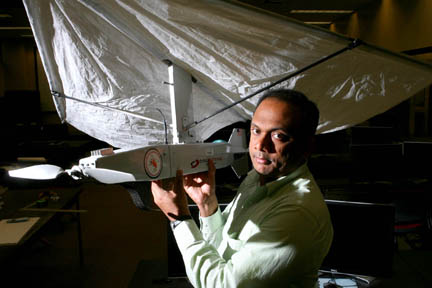
Moreover, initial testing of the program’s unmanned aerial mapping vehicle could happen as early as March – over Louisiana’s barrier islands, Ramachandran said.
“We only require the approval of the Federal Aviation Administration to move forward,” he said.
Currently in its sixth year at Nicholls, the geomatics program is designed to provide college-level preparation that meets the educational requirements for registration as a professional land surveyor in Louisiana. To date, the Louisiana Society of Professional Surveyors has donated around $140,000 to the geomatics program for surveying equipment, recruitment efforts, matching funds for grants and student scholarships.
With around 50 students, the program offers the only bachelor’s degree in surveying and mapping in the state.
For additional information on the geomatics program, call (985) 448-4692 or go to www.nicholls.edu/doas/degree-programs/geomatics/.

